


To avoid disputes, property owners asked to be present during land surveys | Bengaluru News


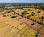
Bengaluru: With the state govt accelerating its ambitious land digitisation drive under the National Geospatial Knowledge-based Land Survey of Urban Habitations (NAKSHA) programme, the state survey and settlement department has issued a clarion call: Property owners must be present during survey work or risk ownership disputes later.The initiative aims to digitise and modernise land records in urban areas using high-resolution drone mappingand ground verification to ensure transparency and accuracy. As part of a pilot rollout, 10 urban local bodies (ULBs) — including six city municipal councils and four town panchayats — were selected across the state. These include Bhagyanagara TP and Siruguppa CMC (Ballari), Boragav TP and Gokak CMC (Belagavi), Basavakalyan CMC (Bidar), Kolar CMC, Bagalkot CMC, Chikkamagaluru CMC, Bogadi TP (Mysuru), and Anavatti TP (Shivamogga).Officials have scheduled surveys on Monday and are urging owners or their representatives to be available on site.”Once the department issues a draft card of property ownership after a survey, owners could raise concerns or queries about ownership,” said J Manjunath, commissioner of survey settlement and land records. “There is a possibility that many owners may approach the department for corrections. If the survey is done in the presence of owners, the number of errors will decrease. So, the department has requested people to be present at their property for survey work.”Drones, flown 120 metres above ground, have already completed aerial surveys in eight of 10 areas. The data was used to generate orthorectified radar images (ORI maps) showing every visible structure and feature, from buildings to drainage lines.Ground truthing, or on-site verification, is now underway to match drone data with physical features. “The department had ORI mapping for Kolar, Sirguppa, and Bhagyanagara before theNAKSHA programme was launched. So, the department began ground truthing work for these three ULBs. In the remaining five ULBs, the drone flyover was completed,” Manjunath said.The Survey of India provide ORI (origin of replication) maps. Once everything is mapped, the department plans to swiftly complete verification and issue ownership records — making early public participation critical.