


Odisha engr among team that developed ‘Knowledge on Sphere’ system | Bhubaneswar News


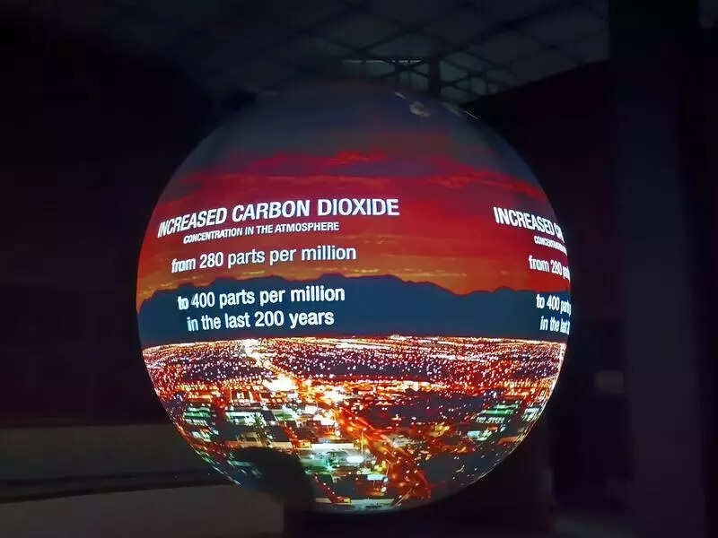
Bhubaneswar: The Central Research and Training Laboratory (CRTL) under the National Council of Science Museums (NCSM) has developed ‘Knowledge on Sphere‘ (KOS), a first-of-its-kind innovation in India that projects visualisations of planetary data onto a six-foot diameter sphere, helping illustrate Earth science to people of all ages.
The indigenous system, which has replaced the previously imported ‘Science on Sphere’ (SOS) from the US, was developed by a five-member team of engineers and scientists, including Odisha-based engineer Suvendu Maharana, within just one year at Rs 80 lakh. The imported system cost Rs 2 crore.
“Earlier, we imported the SOS system from the US, developed and marketed by the National Oceanic and Atmospheric Administration (NOAA), which was an expensive and tenacious process. Now, with our indigenous system, we reduced the cost to less than one-third of the previous amount,” CRTL director Manas Baghchi said.
The new system can display animated images of atmospheric storms, climate change and ocean temperature, explaining complex environmental processes in an intuitive and captivating manner. Additionally, the movement of cyclones and other storms can be monitored through KOS, making it a valuable tool for disaster management and environmental awareness.
“The development of KOS is a landmark achievement in India’s pursuit of technological self-reliance. It not only reduces costs but also empowers us to showcase environmental data in a more engaging and accessible manner. This innovation reflects the potential of Indian scientists and engineers,” A D Choudhary, the director general of NCSM, said.
“The system features globes of 4ft and 6ft diameters, with the first prototype being a dome weighing around 370 kg. Attaining absolute sphericity of the projection surface was a critical challenge, which was successfully addressed by the in-house team,” Choudhary added.
“The system runs on proprietary software developed by CRTL that creates a virtual globe, projects the data onto it using virtual cameras and then corrects the geometry and blends the edges. The content can be controlled and modified using a PC or a tablet, giving educators the flexibility to create playlists from free satellite data sources such as NASA,” Baghchi added.
“The entire process, from conceptualisation to execution, was a great learning experience. I feel proud to be part of this indigenous achievement that brings cutting-edge technology within India’s reach. We gave our best to make the product better than the US,” Maharana said.