


DGPS to make land survey accurate; reduces disputes, provides reliable records | Chennai News – Times of India


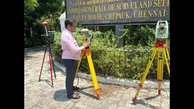
Chennai: Property owners in Tamil Nadu can now breathe easy when it comes to land measurements and boundaries. The state has begun rolling out the Differential Global Positioning System (DGPS)- based land surveying method, replacing age-old chain and tape systems.This cutting-edge technology allows landowners to receive accurate digital maps with coordinates—down to a few centimetres—offering a major leap in transparency and convenience.With nearly 1.4 lakh patta sub-division applications and around 2 lakh non-subdivision requests received monthly by the Commissionerate of Survey and Settlement, the move to DGPS promises faster turnaround, fewer disputes, and more reliable records. For landowners, this means they can track encroachments or verify property boundaries without waiting for traditional surveyors or making multiple visits to the revenue office.”So far, 100 pattas have already been issued using this technology. A key benefit: once a DGPS survey is completed, landowners are provided a field measurement sketch, along with precise latitude and longitude coordinates. This can be used for legal, resale, or dispute-resolution purposes—and can be accessed from anywhere in the world,” said P Madhusudhan Reddy, director of survey and settlement.After successful pilot runs in Namakkal, Ranipet, and Virudhunagar, the technology has now been introduced in Chennai, Chengalpet, Tiruvallur, Coimbatore, and Tirupur. It’s a game-changer, say officials, not just for revenue administration, but for the citizens who rely on clear, certified land ownership records. We are training govt staff on using the technology.Making this shift possible is TN’s extensive DGPS infrastructure. The state is the first in India to establish 70 Continuously Operating Reference Stations (CORS)—permanent GPS stations that ensure sub-centimetre accuracy in positioning. These are all linked to the national reference network, making TN’s digital survey data part of a much larger national grid, said an official.In simple terms, this means landowners will no longer need to request and wait for physical surveys for minor boundary verification or subdivision requests. The process is digital, secure, and accessible. “We have detailed UDR records of over 300 taluks in the state. There are more than five crore patta holders in the state. We welcome the move, but the survey technology, measurement, administration should be done by govt staff and not privatised. It is a crucial department and precision is very important. Outsourced person will not have the responsibility,” said Anna Kuberan, secretary, TN Survey Officers Union.