


Chennai lab to develop lidar-based buoy to improve weather forecast accuracy | Chennai News – The Times of India


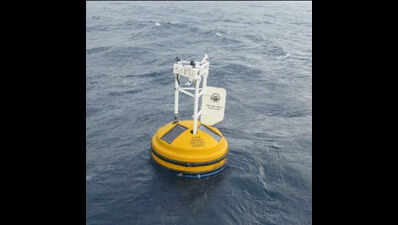
Chennai: A light detection and ranging (LiDAR) system mounted on a buoy moored in the middle of the ocean may soon help improve weather forecast accuracy, including tracking cyclonic storms. Chennai’s National Institute of Ocean Technology (NIOT) is developing it to measure ocean-based atmospheric data, particularly wind speed and direction, aerosols, and cloud characteristics at various altitudes. These are not currently measured from sea-based platforms.
Officials said the LiDAR system will emit laser pulses into the sky and measure the time it takes for the pulses to reflect off a surface and return to the sensor. This will help measure wind speed and direction, as well as cloud characteristics, and track the intensity of storms and the rainfall they may bring as they approach the coast.
“We are also indigenously developing LiDAR buoys under Mission Mausam. The data will be used mainly for weather forecasts,” said Arul Muthiah M, scientist in-charge, ocean oservation sytems, NIOT. “We will initially develop one or two buoys, and later we may develop a network of buoys,” he added.
At present, extreme weather systems such as cyclones and associated cloud formations are tracked using satellites when they are over the deep sea, and ground-based Doppler weather radars when within 250 km of the coast. Periodic observations from the sea will help meteorologists better forecast the path, speed, and potential rainfall of such systems.
The LiDAR aims to fill this gap by offering real-time, sea-based observations when storms or thick cloud formations are over deep ocean waters. This could significantly improve cyclone forecasting accuracy.
Though not directly intended for storm forecasting, the system is expected to aid researchers with advanced data on rain intensity and cloud dynamics — particularly over the Bay of Bengal, where both the southwest and northeast monsoons originate.
Researchers said the existing buoy design is being modified mechanically to accommodate the LiDAR system. This includes redesigning the mast and sensor mounts to hold instruments measuring air pressure, temperature, wind speed, and satellite transmission. Software and algorithms are also being developed to process data from the moving platform.